The Justinian Bridge (Sakarya) — a stone colossus of Byzantium in northwestern Anatolia
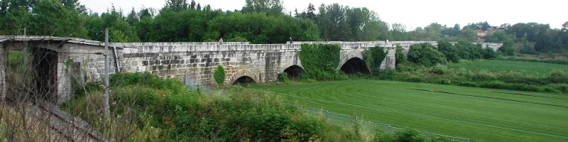
Five kilometers southwest of bustling Adapazarı, Justinian’s Bridge (Sakarya)—a 430-meter-long limestone colossus spanning the narrow Chark-Dere stream, which now flows quietly where the mighty Sakarya once roared. Contemporaries called this structure the “shackles of the river,” and today travelers find a rare sensation here—the feeling of touching the engineering genius of the Eastern Roman Empire. The Justinian Bridge (Sakarya), built between 559 and 562 during the reign of Emperor Justinian I, still stands on seven mighty arches, as if the past one and a half millennia of earthquakes, floods, and wars had never happened. It is one of the largest surviving Late Roman bridges and, at the same time, one of Turkey’s most underrated monuments.
History and Origin of the Justinian Bridge (Sakarya)
The Sakarya River (Sangarius in Latin sources, Σαγγάριος in Greek) has been a major obstacle on the route from Constantinople to the empire’s eastern borders since ancient times. It was here that the military road ran, along which legions marched to the borders of Sassanid Persia—Byzantium’s main rival in the 6th century. Before Justinian’s era, only a wooden pontoon bridge supported by boats spanned the river. The historian Procopius of Caesarea wrote bitterly in his treatise *De Aedificiis* that this floating bridge was regularly swept away by the current during floods, and many travelers perished in the waves.
Justinian decided to build a stone bridge after his inspection tour of Thrace: by the fall of 559, workers had already begun laying the foundation. The chronicler Theophanes the Confessor dates the start of construction to the year 6052 “from the creation of the world,” which corresponds to 559–560 CE. Completion was timed for 562—the same year that Byzantium concluded its long-awaited peace treaty with the Sassanids. The exact date is confirmed by two celebratory poems written in honor of the bridge: one by the court poet Paul Silentiarius, the other by the historian Agathius of Myrina.
It is also believed that the construction was part of a much more ambitious plan—an ancient canal project that had been discussed as early as the 2nd century by Pliny the Younger, then governor of Bithynia, and Emperor Trajan. The plan was to connect Lake Sapanca with the Sea of Marmara and bypass the narrow Bosporus strait. Modern scholar Frank Moore believed that it was Justinian who intended to implement this idea by diverting part of the Sakarya River westward. Michael Whitby objects, arguing that the riverbed was unsuitable for navigation. The debate over the canal remains unresolved to this day, but it is precisely because of this canal that the bridge has attracted the attention of historians for many centuries.
In 1899, a railway line between Adapazarı and Arifiye Station passed by the bridge, partially damaging the eastern section of the structure. In 2018, Turkish authorities submitted an application to include the structure on the UNESCO World Heritage List, and in 2020, the “Justinian Bridge (Sakarya)” was granted tentative list status.
Architecture and What to See
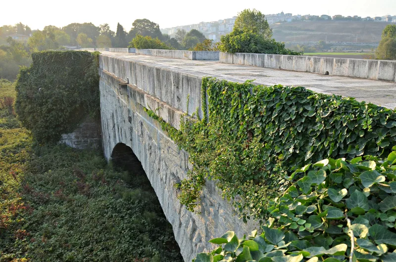
The bridge is impressive even against the backdrop of modern highway overpasses. With a total length of 429 meters, a roadway width of 9.85 meters, and a height of up to 10 meters, its scale is more typical of a small fortress than a bridge. The structure is built entirely of limestone blocks, tightly fitted together without any modern fasteners.
Seven main arches and their geometry
The main load-bearing structure of the bridge consists of seven large arches. The five central spans are 23 to 24.5 meters wide, with supports between them about 6 meters thick. These arches are flanked by two smaller ones—with spans of about 19.5 and 20 meters. If we list the numbers in a dry sequence from west to east, the widths of the spans and supports look like this: 3 (—) 7 (9.5) 19.5 (6) 23 (6) 24.5 (6) 24.5 (6) 24 (6) 24.5 (6) 20 (9.5) 9 (—) 6 (—) 3. Five more small arches (two on the west, three on the east) with spans of 3–9 meters have been added along both banks—these are flood spillways in case of overflow.
Water cutters, on the contrary—a Byzantine ingenuity
A remarkable feature that distinguishes the bridge from most known Roman counterparts: its piers are rounded on the upstream side and tapered on the downstream side. In classical Roman bridges, it is usually the opposite—a sharp wedge meets the current. The widest, western pier is wedge-shaped on both sides. It was precisely this inversion that gave Muru reason to suggest that Justinian was indeed preparing to divert the flow of the Sakarya River westward: in that case, the “non-standard” water-cutting grooves would actually be “correct.”
The Triumphal Arch and the Mysterious Apse
A triumphal arch once stood at the western entrance—a “victory portal” typical of Roman tradition. In 1838, the French traveler Léon de Laborde managed to sketch it while it was still standing: a stone portal 10.37 meters high and 6.19 meters wide, with massive columns 4.35 meters thick and a spiral staircase inside one of them. By the 19th century, the arch had collapsed, and today only its foundations remain. On the eastern side, a mysterious apse 11 meters high and 9 meters wide has survived, featuring a semi-dome facing east—its purpose remains unclear: it may have been a chapel or a roadside shrine offering shelter to travelers.
Crosses on the pylons and a lost epigram
Seven main piers were once adorned with small Christian crosses—a symbol of imperial piety and, at the same time, a tacit sign that the bridge was under the protection of heaven. Today, only two of them have survived, barely discernible on the darkened limestone. Above it all resounded a line from an epigram by Agathias of Myra, carved into the stone: “You too, Sangarius, along with proud Hesperia and the people of Media and all the barbarian hordes, whose turbulent flow is disrupted by these arches, have been subjugated by the sovereign’s hand. Once impassable to ships, once untamed, you now lie in chains of unyielding stone.” The inscription itself has not survived, but its content was recorded in the writings of Emperor Constantine VII Porphyrogenitus four centuries later—thanks to Byzantium’s literary legacy, the voice of the 6th-century engineers, proud of their victory over the capricious river, has reached us.
Interesting Facts and Legends
- The Turkish folk name for the bridge is Beşköprü, “Five-Bridge,” referring to the number of large arched spans visible from afar. The structure is still listed under this name on some local signs today.
- An academic debate continues to this day: was the Justinian Bridge part of a gigantic canal intended to connect the Black Sea with the Sea of Marmara, bypassing the Bosphorus? Frank Moore’s theory, supported by the research of Siegfried Frohhip, presents the bridge as a testament to one of the most grandiose unrealized engineering projects of antiquity.
- Procopius, while describing the bridge in his book *On Buildings*, was simultaneously working on his famous *Secret History*, in which he spared no criticism of Justinian. This resulted in a rare situation: the same author simultaneously praised and cursed the patron—and it is precisely thanks to this duality that we know the exact date of the bridge’s construction.
- In 1899, a railway line—a local section of the Anatolian Main Line—was laid beneath one of the eastern arches. Today, trains rumble almost directly beneath the arches, and the sight of steam locomotive smoke against the backdrop of Byzantine stone long remained a favorite motif on Ottoman postcards.
- Agathias’s epigram is, in fact, an ancient act of “taming” the river: in his lines, the Sakarya is described as subdued by “shackles of unyielding stone,” on par with the vanquished barbarian peoples. For the Russian reader, this echoes Pushkin’s “With an iron bridle, he reared Russia up on its hind legs”—the same rhetoric of subjugating the elements to the will of the ruler.
How to get there
The bridge is located in Sakarya Province, in the village of Beşköprü, southwest of Adapazarı. Exact coordinates: 40.73736° N, 30.37276° E. From Istanbul—about 150 kilometers via Highway O-4 (E80); the drive takes 1.5–2 hours depending on traffic at the entrance to the metropolis.
The most convenient way to travel is by rental car: the highway is modern, and parking near the bridge is free and almost always available. An alternative is the YHT high-speed train from Istanbul (Pendik Station) to Arifiye or Adapazarı, with a travel time of 1 hour and 20 minutes. It’s about 4 kilometers from Arifiye Station to the bridge; you can take a taxi for 5–7 minutes or walk along the river for 50 minutes. From Adapazarı, local dolmuşes (minibuses) run toward Arınca and Beşköprü—all drivers know the landmark “Justinianus Köprüsü.” For those arriving directly at Istanbul’s IST Airport, the easiest option is to rent a car right at the airport: in just two hours, you’ll be standing beneath the 6th-century arches.
Tips for travelers
The best time to visit is late spring (April–May) and early fall (September–October). In summer, the valley heats up to 91–95 °F, there is almost no shade on the bridge, and you won’t find any tourist cafes or kiosks nearby—be sure to bring water, a hat, and sunscreen. In winter, it’s damp and windy here, but deserted: photographers will get perfectly empty shots with fog over Chark-Deresy.
Allow at least 1–1.5 hours for a leisurely exploration: walk the length of the bridge twice (different views of the apse and water channels open up in both directions), and descend to the stream on the south side to examine the masonry from below. You’ll need shoes with grippy soles—the marble slabs are slippery in places, and thick grass grows on the surrounding slopes. Drones legally require a permit in Turkey, but photography from the ground is unrestricted and encouraged.
It’s convenient to combine a visit here with a trip to Lake Sapanca (15 km to the west)—there are lakeside restaurants, trout farms, and quiet villages there. Another logical combination is the Maashukiye Waterfall in Kocaeli (a 40-minute drive) and the ruins of Nicaea (Iznik), an hour’s drive to the southeast, where the famous Ecumenical Council took place in the 4th century. For a Russian-speaking traveler coming from Istanbul, this is an ideal one-day loop: the Byzantine Bridge in the morning, lunch on the shores of Sapanca, and in the evening—a return to the city via the same E80 highway, which actually runs over the old Roman military road.
Practical information: no admission fee is required, the site is open 24 hours a day, and there are no fences—but that is precisely why an unspoken rule of quiet respect applies here. Do not climb the surviving cross-shaped pylons, do not chip off pieces of limestone “as a souvenir,” and do not build fires under the arches. A millennium and a half ago, an imperial military road stood here, traveled by legions, messengers, and Justinian himself; today, Justinian’s Bridge (Sakarya) remains a rare monument where one can touch the stone that remembers Procopius, Agathias, and an era when engineers viewed rivers as enemies to be chained within arches.